Hydroinformatics ▪ Climate Change ▪ Remote sensing ▪ GIS ▪ Modelling.
CN-Idris: An Idrisi tool for generating curve number maps and estimating direct runoff
Software availability
Developer: Rafael Hernández-Guzmán
Contact address: INIRENA-UMSNH. Av. San Juanito Itzícuaro s/n. Col. Nueva Esperanza. CP 58330. Morelia, Michoacán, México
Email: rhernandez.g@gmail.com
First year available: 2010
Software requirements: IdrisiAndes or Idrisi Taiga software
Hardware requirements: PCs with Windows.
Programming language: Visual Basic 6.0
Programming size: 0.32 Mb
Availability and cost: CN-Idris and data samples are free of charge.
Description
We developed a raster-based Geographic Information Systems (GIS) tool called CN-Idris that outputs runoff estimates from land use/land cover and hydrologic soil group maps based on the Natural Resources Conservation Service Curve Number method. The tool enables the user to select among three antecedent moisture conditions and two values of the initial abstraction (Ia) parameter, and it has the option to include spatial variation in rainfall input.
CN-Idris Logic
Following figure show the procedure to estimate runoff in a raster environment:

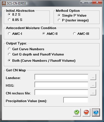
CN-Idris Interface
Following figure show CN-Idris interface:
How to cite
Hernández-Guzmán R., Ruiz-Luna A., Berlanga-Robles C.A. (2011). CN-Idris: An Idrisi tool for generating curve number maps and estimating direct runoff. Environmental Modelling and Software, 26: 1764-1766. https://doi.org/10.1016/j.envsoft.2011.07.006